A prolonged and record heat wave builds over the West this week

– Some of the hottest temperatures of the year are on the way for the West Coast and possibly staying dangerously hot through Labor Day as a mega heat wave builds in for the long term.
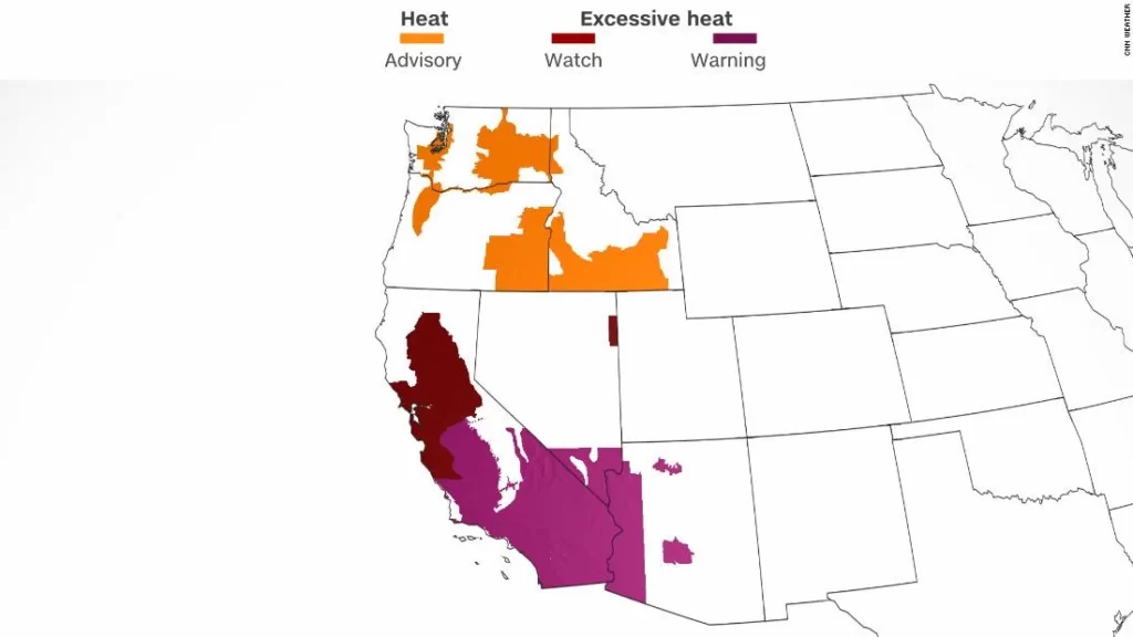
More than 55 million people are currently under heat alerts from Southern California through the San Joaquin Valley and into portions of the Northwest, including 20 of the most populated cities up and down the West Coast.
“Temperatures could exceed 110F in parts of the Southwest, where an excessive heat warning is currently in effect,” the Weather Prediction Center wrote.The most dire areas will be in the Southwest, where the heat will be the most intense.
“Some records may be broken but record max temps are very high at this time of the year,” said the NWS office in Los Angeles. “Record breaking or not, this prolonged heat wave is going to be very dangerous.”

More than 100 records could fall in the West.
Prolonged heat wave for the Southwest
The kind of heat that will be felt from San Diego to Los Angeles to even Phoenix will be difficult to endure even for the locals.
“This heat may be record breaking and will produce a very high risk of heat illness,” said the NWS office in Los Angeles. “Triple digit heat is expected for many valley and mountain locations. Even hotter conditions are expected over the Labor Day weekend into early next week.”
The heat will begin Tuesday, with a gradual warm-up each day through the week, and it will peak by the end of the week.
The reason for the extreme conditions is a stubborn area of high pressure sitting over the region, creating what meteorologists call a “heat dome.”
This intense heat dome causes high pressure to act as a lid on the atmosphere. As hot air attempts to escape, the lid forces it back down, warming even more as it sinks.
The result will be intense summer heat, running 10-15 degrees above normal.
“Excessive Heat warnings are in effect for almost the entire forecast area starting Wednesday and continuing all the way through next Monday,” noted the NWS office in Los Angeles.

The forecast shows temperatures of 110-115 degrees in the deserts and San Fernando Valley, with temperatures running 90-100 along the coast. That’s hot enough to potentially break records there as well.
In Phoenix, the “dry heat” will give way to more humid conditions by Thursday and Friday.
This will cause the actual temperature to fall slightly, but the NWS in Phoenix warns that the humidity could actually make it feel hotter.
In Southern California, a few morning clouds Friday morning could edge in, giving a brief reprieve from the heat — but it will be short-lived.
“There will be renewed warming leading to a kiln-like day on Sunday,” said the NWS office in Los Angeles.
Even downtown Los Angeles could hit 100 degrees on Sunday with Death Valley potentially hitting 125.
This heat extends all the way into the San Joaquin Valley, where record-breaking temperatures are possible.
“Confidence is increasing in this being the hottest temperatures so far this year,” said the NWS office in Hanford, California.
“Record high temperatures are possible beginning Thursday with the best chances for record highs on Sunday and Monday when the peak of the heat is expected.”
The Labor Day holiday will be one of the hottest days of the event, with the heat potentially lasting through much of next week — making heat-related illness a huge concern amidst the oppressive heat.
Record heat for the Pacific Northwest
Maximum heat for interior portions of the Pacific Northwest will be felt through much of this week, as high temperatures soar, including in Seattle, Portland and Boise.
“Daytime highs between 10-20F above normal and nighttime lows between 15-20F above normal are likely,” said the Weather Prediction Center.
The heat is expected to peak on Wednesday with highs in the 90s and potentially hitting the triple digits for portions of the Western Basin, near Spokane, Washington — even breaking records.
“Highs are slated to top out upwards of 10-15 degrees above average as several locations could test daily records for max temperatures,” said the National Weather Service in Seattle.
Near Boise, Idaho, temperatures could reach 20 degrees above normal, with record heat expected through Tuesday.
And in Seattle, high temperatures are expected to top out in the upper 80s to low 90s.
The extreme heat should break by the end of the week, resulting in temperatures back in the 70s for Labor Day weekend.
A Labor Day tropical system could be on the horizon
The tropics are also heating up ahead of the holiday weekend.
The National Hurricane Center is actively watching two areas in the Atlantic for tropical development, as we will most likely have our next named tropical system before Labor Day.
An area of low pressure several hundred miles east of the Lesser Antilles has the greatest potential of becoming “Danielle.”
“Although environmental conditions are only marginally conducive, some gradual development of this system is expected over the next several days and a tropical depression is likely to form later this week,” said the NHC.
inline
There’s an 80% chance of this area becoming a tropical system within the next five days, according to the NHC.
Forecast models take this system to the west, staying north of the Caribbean Islands and curving to the north, avoiding the Bahamas.
The storm should stay out to sea as of now, but things could change between now and next week.
Even though the storm should stay out to sea, there will still be implications for the Eastern Seaboard during the Labor Day weekend.
The storm could create breezy conditions and even strong rip currents for the East Coast. How close the storm gets to the US will determine just how strong the winds and rip currents will be. Closer to the coast they will be stronger, farther from the coast they will be weaker.
The NHC is no longer tracking the area in the western Caribbean for development. However, that region is still producing clouds and rain that will pump tropical moisture into the Texas coast. That will increase the rain chances in South Texas through the Labor Day weekend.
How to prepare for hurricane season
Another area to watch is a tropical wave just off the coast of Africa. This area could also become a tropical depression during the next few days though its life span could be short-lived.
“By late this week, the disturbance is forecast to move over cooler waters and further development is not expected,” said the NHC.
Sandeep Raiza — Content Writer, Website Designer, SEO Strategist, and WordPress Expert AI specialist delivering impactful digital solutions that drive business growth.Combining creative storytelling with technical expertise.


